LAND AT THE DOWNS,
STANDLAKE
Our public consultation period has now ended.
We will now take the time to carefully review the feedback received before the submission of an outline planning application to West Oxfordshire District Council later this year.
Welcome.
You can use this website to view more information about Mac Mic’s proposals for up to 200 new homes and a local convenience store as part of a high quality, sustainable new development in Standlake.
THE SITE
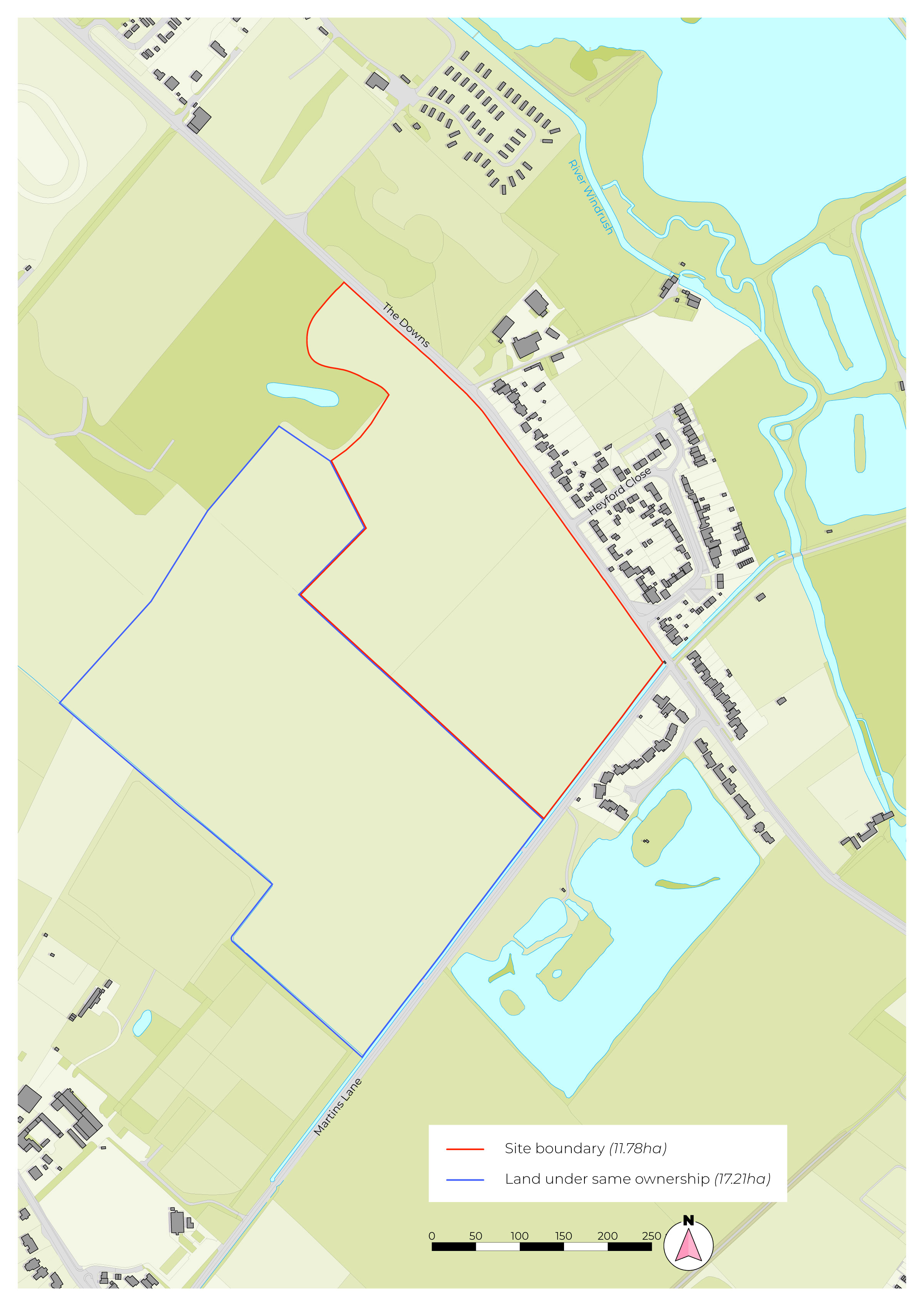
The proposed development site is located to the south of The Downs on the northern edge of Standlake, within a short distance of existing services within the village.
Overall, there are likely to be over 10,000 households that cannot afford to buy their own home on the open market and aspire to homeownership in West Oxfordshire over the period 2025-41. With that in mind, the scheme will make an important contribution to local affordable housing needs by providing 200 new homes, at least 40% of which will be affordable.
The Council recognises that more social rented homes and affordable homes are needed in order to reduce the waiting list, which is under considerable pressure due to housing demand.
Our proposal for Land at The Downs can help alleviate pressure on the Council's waiting list by providing a policy compliant number of affordable homes to meet local needs.
The site currently comprises arable fields with low lying hedgerows and trees, with pockets of woodland to the western and eastern boundaries. To the east of the Site is a lake separated by the designated bridleway of Martins Lane. Towards the south of the Site lies a cricket pitch for the Oxford Downs Cricket Club, adjoining Abingdon Road.
Land at The Downs has been identified as a sustainable location for potential future development of up to 200 homes and a convenience store in the emerging West Oxfordshire District Council Local Plan.
About Mac Mic
Mac Mic Strategic Land is an award-winning UK land and property company, established in 1925. The company is deeply rooted in family values and a long-term vision, with an average team service length of 11 years, more than double the UK average. Mac Mic Strategic Land is dedicated to providing high-quality homes and building enduring communities.
For over a century, Mac Mic has been committed to acting responsibly towards its communities, partners, and people — aiming to deliver positive change and sustainable development. The company supports local communities and charities, and is considerate of the environment. This commitment is reflected in their recent Building with Nature (BwN) excellence award for a site in in Bath and North East Somerset, which showcases best practices in creating spaces that promote wildlife, wellbeing, and water management.
What are we proposing?
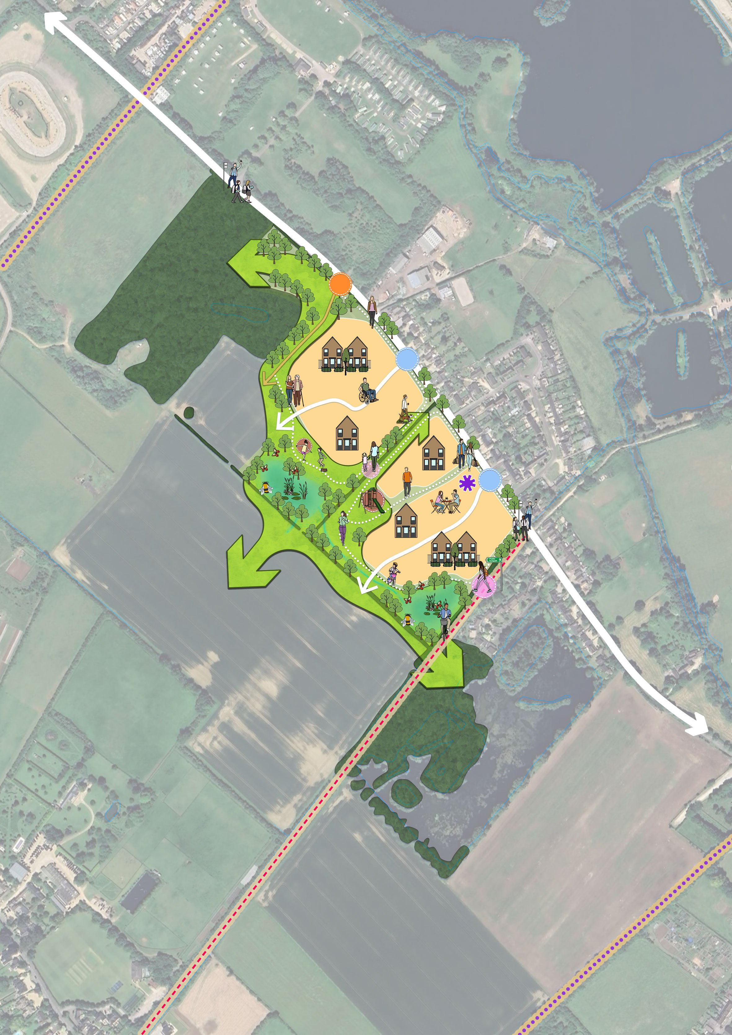
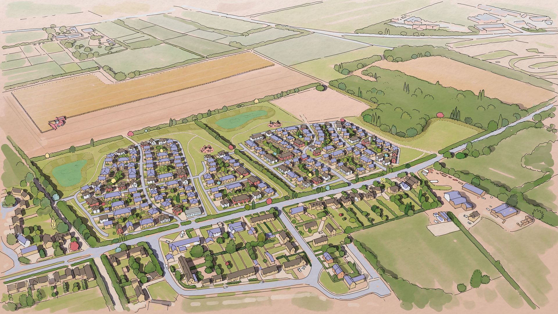
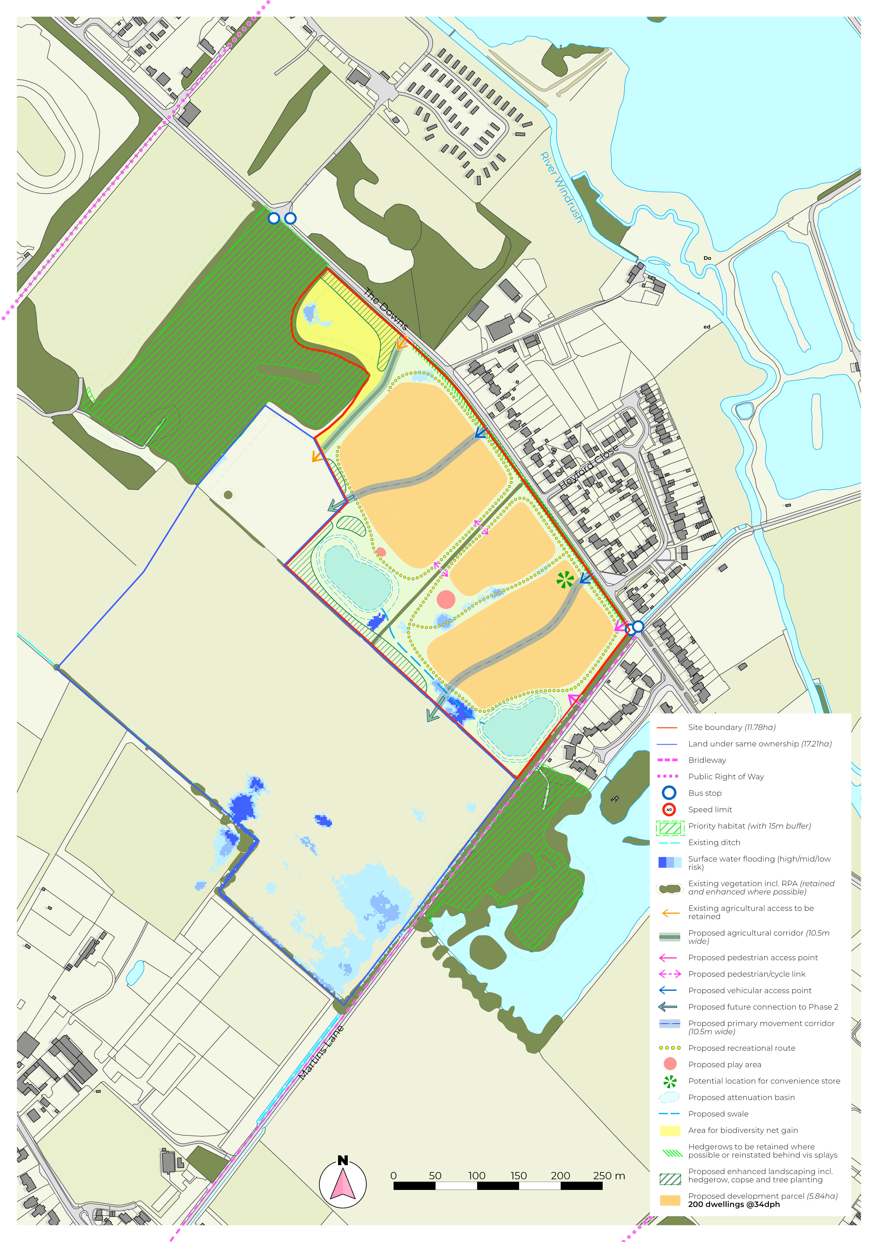
Our vision for the site is to create a high quality, landscape-led community that integrates with the existing landscape and context of Standlake to deliver a sustainable extension to the northern edge of the village.
The application proposes up to 200 sustainable homes in a mix of type and tenure suitable for both younger and older generations, alongside a convenience store to provide additional amenities and facilities for new and current residents in line with the emerging Local Plan vision for the site.
The application will deliver a number of key benefits for the local community including:

Of the 200 homes, at least 40% will be affordable which will make an important contribution toward West Oxfordshire’s housing needs and help allow people who cannot afford a home to continue living and working in the local area.

Landscaped areas along The Downs which will create a clear gateway into the development and village.

A convenience store of around 200 sq.m. will be delivered to provide additional facilities for both the development and existing village.

New public open space, children’s play areas and natural play trails.

An overall increase in biodiversity of at least 10%.

Walking and cycling routes throughout the development providing connections to the open green spaces within the site, creating an attractive environment for people to live and improving the health and wellbeing of the community.

Wildlife-friendly sustainable drainage features to manage surface water including swales and attenuation ponds, which will ensure there is no increased risk of flooding elsewhere.
Access and movement

The proposed primary access into the site will be via The Downs. There will be two main vehicular accesses into the site and the primary access will also have a cycleway and footpath on both sides of the road linking to existing footpaths beyond the site.

Non-vehicular access and connectivity will also be provided from the existing bridleway/PRoW along Martins Lane located along the eastern boundary.

The Site has a great opportunity to incorporate additional safe and high quality recreational routes throughout the development to enhance connectivity and promote walking and cycling, health and wellbeing through circular routes.
a
The proposed primary access into the site will be via The Downs. There will be two main vehicular accesses into the site and the primary access will also have a cycleway and footpath on both sides of the road linking to existing footpaths beyond the site.
Non-vehicular access and connectivity will also be provided from the existing bridleway/PRoW along Martins Lane located along the eastern boundary.
The Site has a great opportunity to incorporate additional safe and high quality recreational routes throughout the development to enhance connectivity and promote walking and cycling, health and wellbeing through circular routes.
Flood Risk and Drainage
The site is located outside of Environment Agency Flood Zones, meaning it has the lowest possible probability of river and sea flooding. However, parts of the site are currently susceptible to surface water flooding.
The drainage strategy for the site will include the provision of attenuation ponds as part of a sustainable urban drainage system to manage surface water within the development, ensuring no existing or future properties will be at risk of flooding. These features will be wildlife-friendly to support biodiversity net gain.
In regard to foul drainage, we understand the issues being faced locally with sewage capacity and the difficulties Thames Water are facing, which are a matter of public record. However, Thames Water have a statutory responsibility to provide capacity for new developments. It is likely that a condition of future development on the site will require the developer to agree an infrastructure improvement plan with the local authority before any of the new homes can be occupied.
LANDSCAPING
The site is located between two pockets of woodland which are located on both the northern and south-eastern boundaries. A buffer will be included to protect natural habitats and the character of the surrounding area.
Features incorporated as part of the drainage strategy will form part of a new network of green corridors with new tree planting along existing hedgerows, connecting a series of green spaces that will promote active travel for residents.
Constraints and opportunities
VISION